|
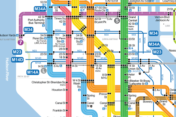
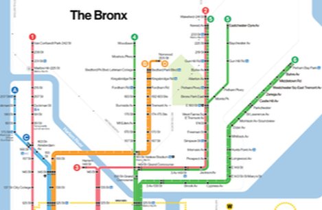
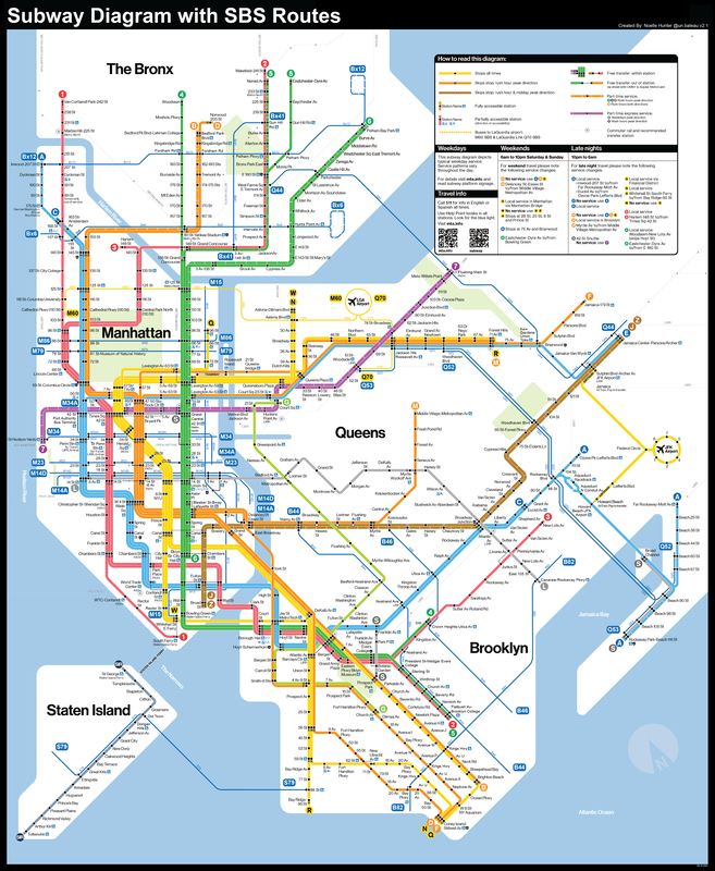
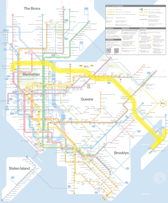
This post is a text version of this YouTube video: https://youtu.be/P1GsBU8BAL4 New York's subway system is quite easy to conceptualize, even if its intricacies are confusing at times. Signs in stations direct commuters towards their desired trains, which travel all around the city. The simplicity of this concept at its core is, in no small part, a consequence of having a clear, well designed map to navigate the system. Personally, I have a preference for the new Vignelli-style maps that the MTA has been producing, because it gives much better clarity of lines and their relationships between each other. It's also just a very clean, aesthetically pleasing design. Compare this to NYC's bus map, and the difference is immensely striking. Since the bus system utilizes the street grid as its foundation, the map becomes very convoluted and hard to decipher. Despite the city's best attempts, I don't think there's any good way around this, because the sheer number of routes and their complexity prevent any map from reading as clearly as that of the subway system. This is particularly unfortunate because many transit experts agree that a formidable bus system is to a city as a foundation is to a skyscraper–they provide the basis for each structure. However, there is a certain type of bus that the MTA has designed to act more like the rapid transit system that we expect from, say the subway: the Select Bus Service (SBS). Because New York doesn't have BRT quite yet, the SBS system is the closest we have to rapid transit-like service in areas the subway doesn't yet cover. Take the Bronx for example: no subway route runs crosstown in the borough, even though residents clearly need more crosstown connections. However, the Bx12 SBS and Bx6 SBS make up for these missing links, as much as they can. Though the Select Bus Service lacks the dedicated rights of way that would make it a comprehensive, long term solution to these crosstown connections, it's a step up in creating better transit across the city. Unlike the subway system, the Select Bus Service doesn't have its own dedicated map, which makes it more of a secret feature in the midst of a tangled bus network. What's more is that including an SBS dedicated map would help fill in the gaps where the subway has yet to reach. In fact, incorporating the SBS routes into the subway map could help commuters conceptualize New York's transit system as an integrated network of different modalities. Thinking of transit in this way opens up new routes and connections that we might not have thought of otherwise. As we turn towards new investments in infrastructure, considering different modes such as buses as valid transportation solutions for certain areas is crucial. After all, it opens up new corridors and options to strengthen the efficacy of the current system. So let's incorporate the SBS routes into the subway map, turning it from a representation of one single transit mode into a diagram of multiple transit modalities. Several cities already represent their transit systems this way, with LA integrating BRT busways into their metro diagram and London's tube map having numerous modes as well. Below is what I've come up with: This isn't the highest quality edit, but I think it makes a functional transit diagram that someone could use on their daily commute. Overall, it really helps fill in a lot of underserved areas and make it more apparent that decent transit options exist. Representationally, I decided to go with a smaller line weight for the SBS routes to visually communicate that they're not quite the same frequency or capacity as the rail lines. I also made the choice to include station dots where each bus intersects with a subway station, as I feel it makes transfers and connections easier to understand. However, I didn't use those dots where multiple SBS routes intersect, partly because it was hard to fit all that information into the map, but also because transfers between bus routes don't function in the same way as subway station transfers. Showing the SBS lines in this way also helps illustrate major corridors for potential future subway extensions. Apart from the 2nd Avenue and Interborough Express lines, which are already in the works, extending a subway down Utica and Nostrand Avenues should remain top priorities for the MTA to relieve congestion on B46 and B44 routes. Investing in the Bronx by upgrading the Bx12 and Bx6 are also important issues, although these tasks are a little less straightforward. Unfortunately, planners never left room for strong mass transit crosstown routes in the Bronx, and this makes it a bit more complicated to construct in the modern day. An upgrade to the Bx41 is perhaps the most straightforward for the borough, as its route runs right next to Metro North's Harlem line. Fare integrating this commuter rail segment as well as constructing additional infill stations remains a worthwhile investment. One interesting note is that a general corridor seems to have emerged. The M60, Q70, Q52, and Q53 buses form a distinct route through Queens and crosstown into Manhattan, albeit a very fragmented path. The presence of SBS lines here suggests that if the city wanted to construct a completely new line, this would be a compelling location. From a formal and conceptual perspective, this is a very strategic, lateral route that could not only connect both LGA and JFK to almost every single train line, but also fortify the existing network into a strong web of intersecting lines. The QueensLink plan proposes a similar connection south of Queens Boulevard, and if the 2nd Avenue subway ever makes its way across 125th street, then these projects could form the basis for the creation of such a link. Additionally, this connection presents the possibility to connect uptown and Bronx residents to LaGuardia Airport in the future. A crosstown line between Flushing and Jamaica also remains a vital connection that would benefit from a subway upgrade. However, an equally compelling solution is to convert the Q44 bus, which currently serves this route, into a full BRT line with dedicated rights of way. Simply upgrading this bus would still allow it to run crosstown in the Bronx as well without the expensive cost of building a new bridge or tunnel for the subway. However, the details of such a plan are a discussion for later. Upgrading the S79 to BRT in a similar fashion also presents a cost-effective method to grant Staten Island better transit access, given that density in the borough probably isn't high enough for an expensive subway tunnel under the narrows. The MTA could connect such a route to the North Shore BRT, a project already in progress, to create a much better integrated transit line overall. Some of these plans are, of course, controversial, but for the time being, they remain as ideas. Any new transit project like this requires a large amount of community outreach and planning to achieve the modality and alignment that is best for the neighborhood, and city at large. It can not, and should not, be solely based on my one opinion. After all, what is the virtue of transit if not to help the people as a whole?
0 Comments
Your comment will be posted after it is approved.
Leave a Reply. |
Archives
May 2023
Categories |

